Fenwick to Lindisfarne (Holy Island) along the St. Cuthbert’s Way
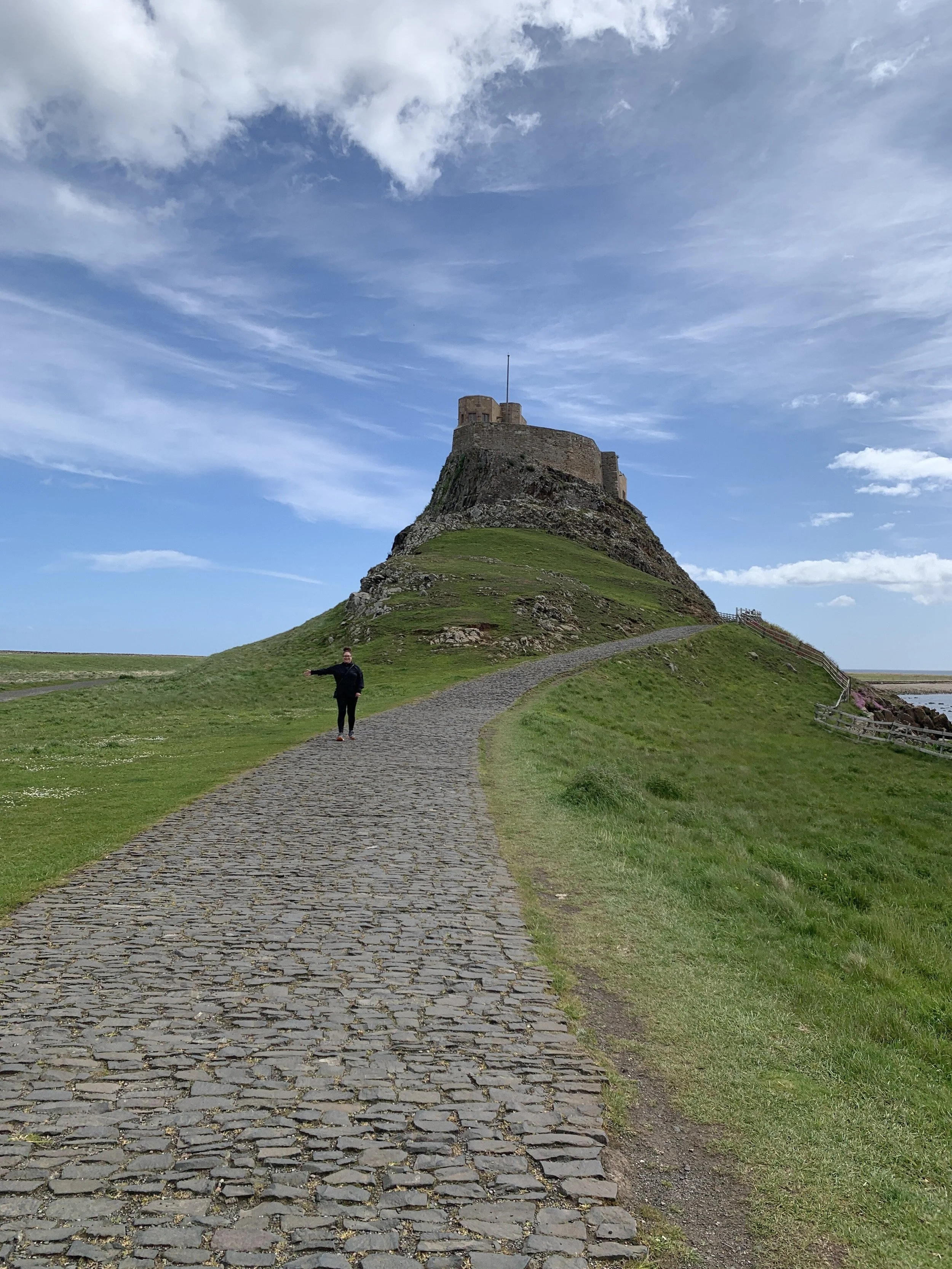
The castle on Holy Island
Fenwick to Lindisfarne (Holy Island)
6 miles/9.6 km, ascent: 50 ft./15.25 m
The last day! This is always a bitter-sweet day, the end of the journey, the end of your aching feet, the end of the conversation you have along the trail. But the satisfaction of completing something so challenging, that a few years ago you could never dream of doing, is overwhelming.
When planning this section, you should do a little homework. Holy Island is a tidal island and the tide goes in and out every 5 hours. The tide times are posted by the causeway, but you will need to Google them to plan your day well. The walk from land to the island is 3 miles and you have 3 miles to go before you reach the crossing point. There are all kinds of local stories about people getting caught in the tide. It is a £8,000 helicopter rescue if you try to cross at the wrong time, so do the homework and have a strong finish.
After another perfect rustic transfer back to where we left off the day before, we started off in great anticipation for the crossing. We were lucky with the tide on that day because the low tide was at 11 am. It could not have been any better. We slept in and walked the first 3 miles slowly (an hour and a half) before arriving at the sand.
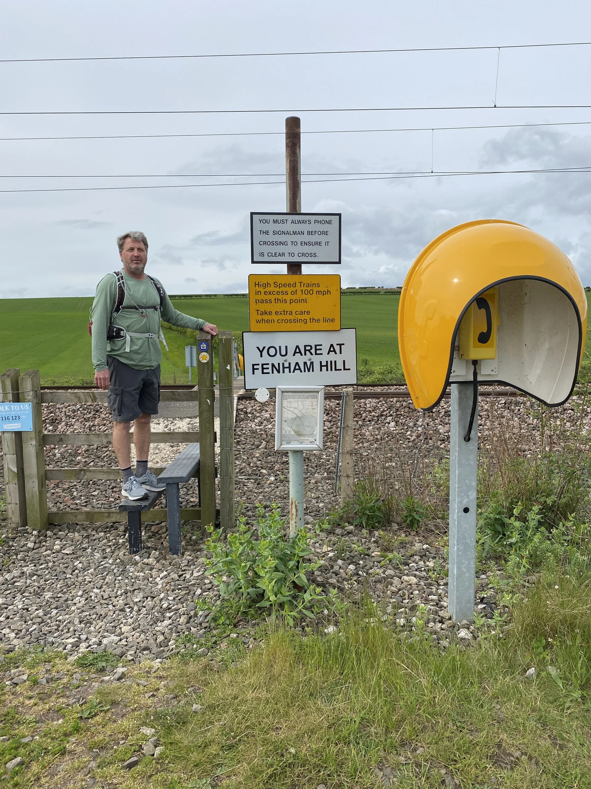
Phone booth and signs before crossing the railroad tracks
The first 2.5 miles were pretty much one long, straight, grassy path set between two fields. Then you come to the train tracks. This was a seriously cool process for crossing train tracks, put in place for people walking St. Cuthbert’s Way. We approached a bright yellow phone booth with the word “danger” and “you cannot cross the railroad tracks until you have called the operator and have been cleared”, written on a sign before the gate. We called the operator and asked if it was safe to cross. The operator on the other side said “no, it is not safe to cross right now call me back when the train has passed”. Hanging up the phone we looked in both directions and as far as the eye can see there were NO trains. We were baffled. We were just calling because it was funny and we wanted to follow the rules. A minute later, a fast train came whipping by us out of nowhere going, we were told, 130 mph. We very easily could have been on the tracks. We called the operator back and asked if it was safe to cross, “yes, it’s safe” said the operator. The tracks were 4 lanes deep and far apart, after climbing stairs over a fence on both sides it took us maybe 3 to 4 minutes as a group to cross. We were very glad we called!

Traditional pilgrim’s path across the sand at low tide
The traditional pilgrim’s path across the sand is the most authentic way to walk the 3 miles to the island. There is a causeway that is busy with tourist buses and delivery trucks, but you can choose to walk this way and keep your shoes on. After some discussion, our group decided to take our shoes off, hook them to the back of our backpacks and head out across the sand. I was very reluctant to walk without shoes, not knowing if there would be glass or sharp rocks. But I thought I should be in the spirit of things and hope for the best.
The sand was hard packed in most places with a few lingering puddles, which was almost easier to walk through than the hard sand. The whole 3 miles were covered in little worm-looking shapes that kept growing and bubbling. For a while, we thought they were worms, but they were the paths of clams digging their way to safety. What a relief, we could walk freely without squashing worms.
There was a section about 75 yards long that was slippery, sinking, black mud. I needed a steady arm and some encouraging words from my husband to not fall flat on my face, and most likely not be able to get up. Without him, I think I would have needed to crawl through this section.

Black mud on feet after the slippery section
I was happy to reach the island relatively clean and unscathed, aside from sore feet that felt like someone gave them a solid scrub down with sandpaper. The sand crossing did not have any glass or sharp rocks, only a few sharp broken sea shells.
At the end of the tall marker poles, just as you climb over some large rocks to dry land, there is a bench where you can sit down. We poured our leftover water over our feet, brushed off the sand, and sat for a while until our feet dried enough to put our socks on.
Just beside the bench is a large sign that reads, “Welcome to Holy Island”. We had another walker take a photo of the four of us in front of the sign and counted this as the end of our trek. Unfortunately, there is no official end or signpost to say you have completed St. Cuthbert’s Way. There is a small chapel in the center of town, St. Cuthbert’s Church, where they plan to put a stone plaque outside to mark the official end.
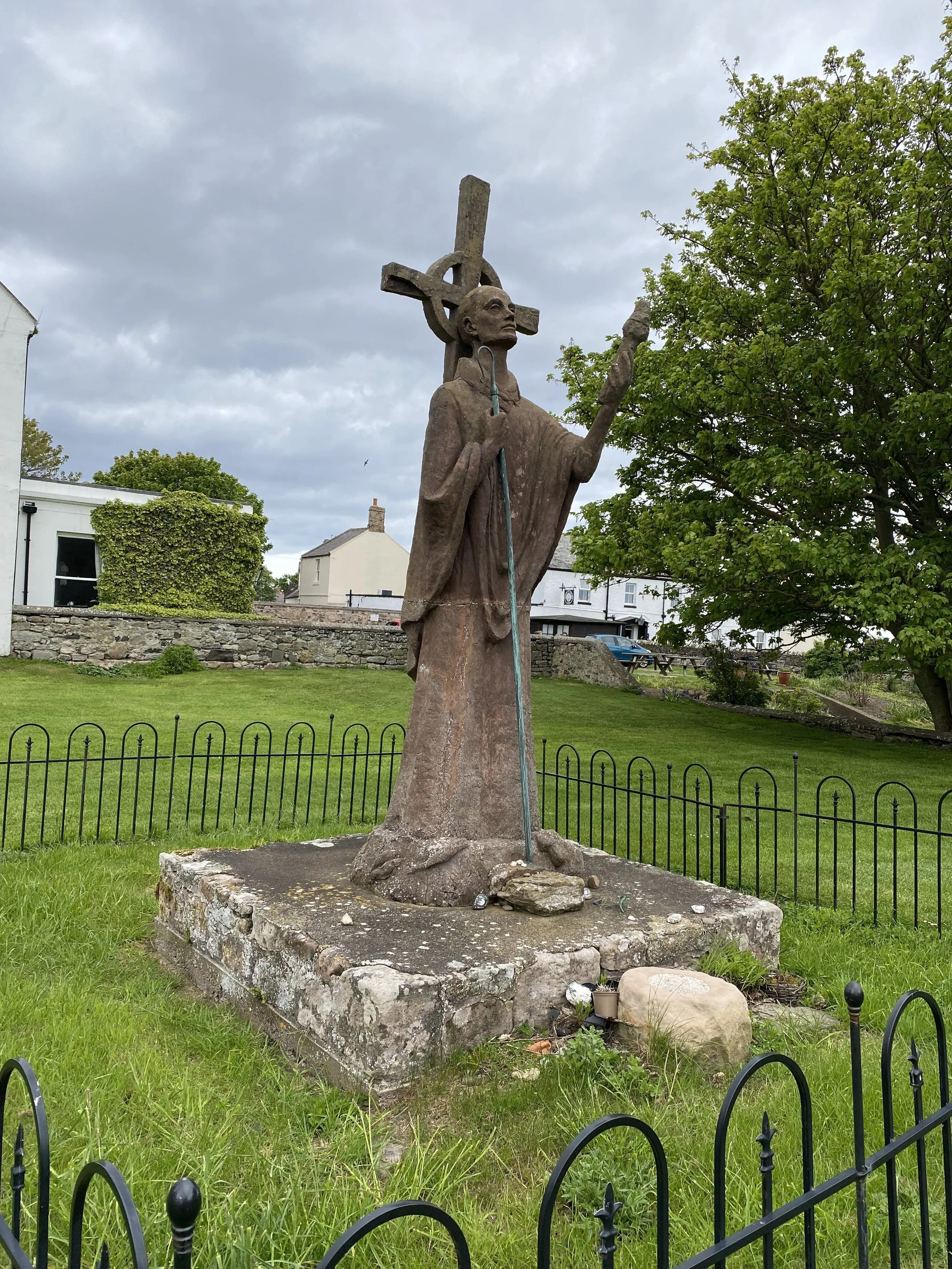
Statue of St Aidan at Lindisfarne Priory could be considered the final waymark
We stayed on the island for two nights so we could wander around the village and tour the castle and abbey. I would highly recommend doing this if you have the time. The village is small with three inns, three pubs, and lots of cute shops, but the real reason to stay is when the tide is due to come back in, the tours and day sightseers leave the island to avoid being stranded. The island quietens, calms, and takes a deep breath from the hustle and bustle of the day.

Quiet and peaceful